Vertical displacement analysis applies GNSS technology with spatial network adjustment and Kalman filtering
Ha Ngoc Hoang1
Keywords:
Abstract
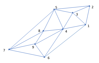
Currently, due to the effects of climate change and the impact of rising sea levels, in some areas of our country there is a phenomenon of displacement and deformation. In the article, the method of analyzing vertical displacement deformation (vertical geodynamic displacement, construction settlement deformation...) has been studied, based on the use of 3D data obtained from the results. Observation grid measurement applies GNSS technology in cycles and Kalman filter theory. The theoretical basis and calculation algorithm for the problem of analyzing and predicting deformation using GNSS technology has been presented. Research results can serve basic investigations in localities with the possibility of subsidence or deformation due to geological faults or environmental impacts.
Downloads