Some discussion on calculations of chart datum in Vietnam
Đoàn Hữu Chinh
Keywords:
Abstract
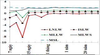
The article mentions the method and results of determining some types of depth reference surfaces (chart datum) from different preriod of the observation data at HONDAU tidal station. The calculation results presented in the article are the results obtained when applying calculation software programmed by the authors themselves using Visual Basic 6.0. The mathematical basis of the method and the calculation results are analyzed and discussed clearly. Some discussions on the relevance and stability of the theoretical lowest water taking into account the influence of shallow water tides are considered to have certain reference value for related industries such as Geodetic mapping, maritime assurance, surveying, design, construction, management and operation of marine structures, etc.
Downloads